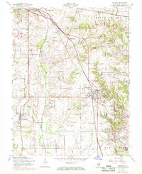
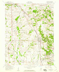
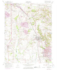
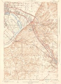
1954 Map of Freeburg
USGS Topo · Published 1969About this map
The rolling hills of Turkey Hill and the agricultural lands south of Belleville define this mid-century portrait of St. Clair County. The landscape is deeply influenced by the transport corridors of the Illinois Central and the Louisville and Nashville railroads, which helped sustain settlements like Freeburg, Smithton, and Wilderman. Extensive industrial activity is visible via a large Strip Mine located between these hubs, showing the region's historical reliance on coal extraction alongside farming. For those researching local lineages, the map is densely populated with community markers, including Holcomb Sch and a significant cluster of burial sites such as Smithton-Franklin Cem, B'Nai Rider Cem, and Walnut Hill Cem. The drainage patterns of Richland Creek and Sugar Creek provide a natural framework for the scattered farmsteads and rural townships of Smithton and Shiloh Valley during this era of post-war development.
Find a feature on this map
39 named features on this map. Tap any name to fly to it.
Don’t see what you’re looking for? This feature index may not catch every label — zoom into the map to look around manually.
Map Details
Editions of this 1954 Freeburg Map
3 editions found
Other maps of this area

1888 · St. Louis
USGS Topo · 1:62,500

1907 · Belleville
USGS Topo · 1:62,500

1910 · Waterloo
USGS Topo · 1:62,500

1912 · New Athens
USGS Topo · 1:62,500

1913 · Waterloo
USGS Topo · 1:62,500

1931 · French Village
USGS Topo · 1:24,000
1935 · Lebanon
USGS Topo · 1:24,000
1935 · French Village
USGS Topo · 1:24,000
1937 · O'Fallon
USGS Topo · 1:24,000

1949 · Saint Louis
USGS Topo · 1:250,000