
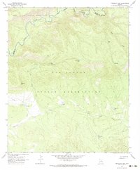
1967 Map of Freezeout Mountain
USGS Topo · Published 1970About this map
The Black River carves a deep, winding path along the northern boundary of this high-elevation landscape, marking the transition between the Fort Apache Indian Reservation and the San Carlos Indian Reservation. The 1967 field survey illustrates a territory defined by its water management and relief, where natural gaps like B S Gap and Malay Gap provide passage through the high country. Resource management is evident through numerous livestock watering sites, including Buckhorn Tank, Loafer Tank, and Cox Corral Tank, which supported the ranching operations within reservation lands. The drainages of Freezeout Creek and Dry Prong Creek descend from the slopes of Freezeout Mtn, while a network of Jeep Trails provides the primary means of traversal across the Apache and Graham county lines.
Find a feature on this map
18 named features on this map. Tap any name to fly to it.
Don’t see what you’re looking for? This feature index may not catch every label — zoom into the map to look around manually.
Map Details
Editions of this 1967 Freezeout Mountain Map
2 editions found
Other maps of this area

1913 · Morenci
USGS Topo · 1:125,000

1915 · Morenci
USGS Topo · 1:125,000

1922 · Nutrioso
USGS Topo · 1:125,000

1954 · Clifton
USGS Topo · 1:250,000

1957 · Clifton
USGS Topo · 1:250,000

1958 · Clifton
USGS Topo · 1:250,000

1958 · Hannagan Meadow
USGS Topo · 1:62,500

1962 · Clifton
USGS Topo · 1:250,000

1967 · Robinson Mesa
USGS Topo · 1:24,000
1967 · Sawbuck Mtn.
USGS Topo · 1:24,000