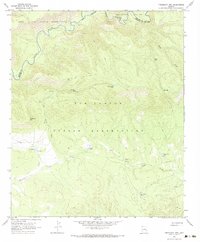
1967 Map of Freezeout Mountain
USGS Topo · Published 1984About this map
Fort Apache Indian Reservation and San Carlos Indian Reservation meet along the winding course of the Black River in this 1967 survey. The landscape is defined by its water management systems, featuring a high concentration of livestock tanks such as Yellow Pine Tank, Buckhorn Tank, and Loafer Tank scattered across the high terrain. These features, along with names like Coz Corral Tank, point to a history of high-country ranching within the reservation boundaries. Significant topographic landmarks like Freezeout Mtn and geological breaks such as Malay Gap and B S Gap provide a framework for navigating the network of Jeep Trails that crisscross the drainage basins of Malay Creek and Dry Prong Creek. The map also captures the administrative divide between Apache and Graham Counties, where the high-altitude landscape transitions between these remote river canyons.
Find a feature on this map
19 named features on this map. Tap any name to fly to it.
Don’t see what you’re looking for? This feature index may not catch every label — zoom into the map to look around manually.
Map Details
Editions of this 1967 Freezeout Mountain Map
2 editions found
Other maps of this area

1913 · Morenci
USGS Topo · 1:125,000

1915 · Morenci
USGS Topo · 1:125,000

1922 · Nutrioso
USGS Topo · 1:125,000

1954 · Clifton
USGS Topo · 1:250,000

1957 · Clifton
USGS Topo · 1:250,000

1958 · Clifton
USGS Topo · 1:250,000

1958 · Hannagan Meadow
USGS Topo · 1:62,500

1962 · Clifton
USGS Topo · 1:250,000

1967 · Freezeout Mountain
USGS Topo · 1:24,000

1967 · Robinson Mesa
USGS Topo · 1:24,000