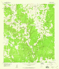
1958 Map of Frelsburg
USGS Topo · Published 1959About this map
Frelsburg serves as the focal point of this late 1950s survey of northern Colorado County, where the landscape is defined by the winding course of Cummins Creek and a network of productive petroleum tracts. The map illustrates a rural Texas economy transitioning between traditional agriculture and modern industrial extraction, prominently featuring the Frelsburg Oil Field and the Columbus Oil Field. Local community life is rooted in landmarks like the St Peter and Paul Sch and the Zimmerscheidt Community Center, while the presence of Kaiser Cem offers a point of interest for those researching local family lineages.
Find a feature on this map
23 named features on this map. Tap any name to fly to it.
Don’t see what you’re looking for? This feature index may not catch every label — zoom into the map to look around manually.
Map Details
Editions of this 1958 Frelsburg Map
3 editions found

Other maps of this area

1919 · Fayettsville
USGS Topo · 1:62,500

1953 · Seguin
USGS Topo · 1:250,000

1956 · Bellville
USGS Topo · 1:62,500

1956 · Glidden
USGS Topo · 1:62,500

1957 · Eagle Lake
USGS Topo · 1:62,500

1957 · Ellinger
USGS Topo · 1:24,000

1957 · Columbus
USGS Topo · 1:24,000

1957 · Borden
USGS Topo · 1:24,000

1958 · Seguin
USGS Topo · 1:250,000

1958 · Industry
USGS Topo · 1:24,000