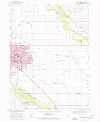
1968 Map of Fremont East
USGS Topo · Published 1977About this map
The Elkhorn River and Platte River converge in this corner of Eastern Nebraska, shaping a landscape defined by fertile floodplains and a dense web of transportation. Fremont serves as the regional anchor, its street grid detailed with essential civic institutions of the late 1960s, including Midland College, the County Hospital, and numerous parochial and public institutions like St Patricks Sch and Clarmar Sch. The industrial and agricultural character of the era is evident in the Chemical Plant north of town and various Sandpits along the riverbanks.
Find a feature on this map
65 named features on this map. Tap any name to fly to it.
Don’t see what you’re looking for? This feature index may not catch every label — zoom into the map to look around manually.
Map Details
Editions of this 1968 Fremont East Map
3 editions found

Other maps of this area

1893 · Fremont
USGS Topo · 1:125,000

1896 · Fremont
USGS Topo · 1:125,000

1899 · Wahoo
USGS Topo · 1:125,000

1955 · Fremont
USGS Topo · 1:250,000

1957 · Fremont
USGS Topo · 1:250,000

1958 · Fremont
USGS Topo · 1:250,000

1966 · Nickerson
USGS Topo · 1:24,000

1966 · Hooper
USGS Topo · 1:24,000

1968 · Valley
USGS Topo · 1:24,000

1968 · Leshara
USGS Topo · 1:24,000