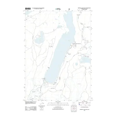
2012 Map of Fremont Lake South
USGS Topo · Published 2012About this map
Fremont Lake dominates this landscape, its deep waters framed by the prominent Fremont Ridge and the Sylvan Bay Summer Home Area along the eastern shore. The map illustrates a high-altitude recreational hub just north of Pinedale, where the glacial geology of the Wind River Range has created a series of water bodies including Soda Lake, Little Soda Lake, and Half Moon Lake.
Find a feature on this map
37 named features on this map. Tap any name to fly to it.
Don’t see what you’re looking for? This feature index may not catch every label — zoom into the map to look around manually.
Map Details
Editions of this 2012 Fremont Lake South Map
This is the sole edition of this map. No revisions or reprints were ever made.
Other maps of this area

1909 · Fremont Peak
USGS Topo · 1:125,000

1955 · Thermopolis
USGS Topo · 1:250,000

1955 · Lander
USGS Topo · 1:250,000

1958 · Lander
USGS Topo · 1:250,000

1958 · Thermopolis
USGS Topo · 1:250,000

1961 · Lander
USGS Topo · 1:250,000

1962 · Thermopolis
USGS Topo · 1:250,000

1964 · Boulder Lake
USGS Topo · 1:24,000

1964 · Mount Airy
USGS Topo · 1:24,000
1964 · Cora
USGS Topo · 1:24,000