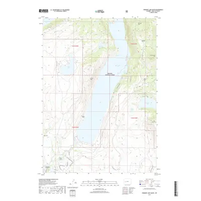
2017 Map of Fremont Lake South
USGS Topo · Published 2017About this map
Pinedale sits at the southwestern edge of this landscape, serving as a gateway to the sprawling glacial waters of the Bridger National Forest. The topography is dominated by the deep basin of Fremont Lake, framed by dramatic elevations such as Fremont Ridge and Higgins Point. The area's complex hydrology is evident in the cluster of smaller bodies like Little Soda Lake, Mud Lake, and Soda Lake, all shaped by the terminal moraines of the Wind River Range. To the east, the terrain rises sharply toward Fortification Mtn and Half Moon Mtn, overlooking Half Moon Lake. Modern residential development is captured along the Pine Creek corridor via Riverside Subdivision Rd, illustrating the town's expansion toward the lakefronts. Traditional land use persists alongside recreation, marked by the presence of the Stock Drive Way cutting across the high southern plateaus.
Find a feature on this map
43 named features on this map. Tap any name to fly to it.
Don’t see what you’re looking for? This feature index may not catch every label — zoom into the map to look around manually.
Map Details
Editions of this 2017 Fremont Lake South Map
This is the sole edition of this map. No revisions or reprints were ever made.
Other maps of this area

1909 · Fremont Peak
USGS Topo · 1:125,000

1955 · Thermopolis
USGS Topo · 1:250,000

1955 · Lander
USGS Topo · 1:250,000

1958 · Lander
USGS Topo · 1:250,000

1958 · Thermopolis
USGS Topo · 1:250,000

1961 · Lander
USGS Topo · 1:250,000

1962 · Thermopolis
USGS Topo · 1:250,000

1964 · Boulder Lake
USGS Topo · 1:24,000

1964 · Mount Airy
USGS Topo · 1:24,000
1964 · Cora
USGS Topo · 1:24,000