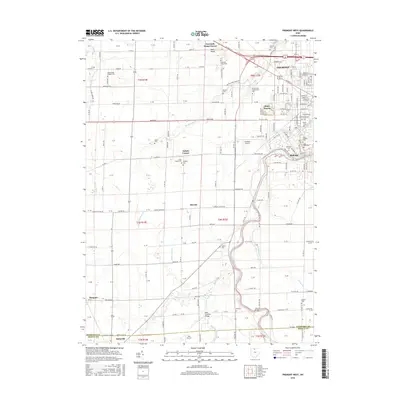
2016 Map of Fremont West
USGS Topo · Published 2016About this map
The Sandusky River carves a path through the eastern portion of this Sandusky County landscape, defining the character of Ballville and the western edge of Fremont. This 2016 survey illustrates the mix of agricultural heritage and modern institutional growth, featuring the sprawling campus of Terra State Community College and the local Fremont Airport. Moving south along the river, the map identifies several historic crossing points and landmarks, most notably the Mull Covered Bridge and the Gilmore Bridge.
Find a feature on this map
165 named features on this map. Tap any name to fly to it.
Don’t see what you’re looking for? This feature index may not catch every label — zoom into the map to look around manually.
Map Details
Editions of this 2016 Fremont West Map
This is the sole edition of this map. No revisions or reprints were ever made.
Other maps of this area

1901 · Fostoria
USGS Topo · 1:62,500

1901 · Fremont
USGS Topo · 1:62,500

1901 · Elmore
USGS Topo · 1:62,500

1903 · Fremont
USGS Topo · 1:62,500

1903 · Fostoria
USGS Topo · 1:62,500

1903 · Elmore
USGS Topo · 1:62,500

1906 · Tiffin
USGS Topo · 1:62,500

1956 · Toledo
USGS Topo · 1:250,000
1957 · Lindsey
USGS Topo · 1:24,000
1957 · Wightmans Grove
USGS Topo · 1:24,000