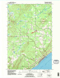
1992 Map of French River
USGS Topo · Published 1995About this map
Lake Superior dominates the southeastern corner of this North Shore landscape, where the rugged terrain of St. Louis County meets the water. The drainage pattern is defined by several parallel watercourses, including the French River, Big Sucker Creek, and the Talmadge River, all flowing toward the lake. The small settlement of Clifton is located along the shoreline, serviced by the Old North Shore Road and North Shore Drive, which follow the natural curve of the coast.
Find a feature on this map
18 named features on this map. Tap any name to fly to it.
Don’t see what you’re looking for? This feature index may not catch every label — zoom into the map to look around manually.
Map Details
Editions of this 1992 French River Map
This is the sole edition of this map. No revisions or reprints were ever made.
Other maps of this area

1895 · Duluth
USGS Topo · 1:62,500

1953 · Lakewood
USGS Topo · 1:24,000

1953 · French River
USGS Topo · 1:24,000

1953 · Arnold
USGS Topo · 1:24,000

1953 · Duluth
USGS Topo · 1:24,000

1953 · Knife River
USGS Topo · 1:24,000

1953 · Duluth
USGS Topo · 1:62,500

1953 · Ashland
USGS Topo · 1:250,000

1953 · Duluth
USGS Topo · 1:250,000

1954 · Barrs Lake
USGS Topo · 1:24,000