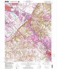
1998 Map of French Village
USGS Topo · Published 1999About this map
French Village sits at the intersection of a complex transit and residential landscape in St. Clair County, where the transition from the Mississippi River bottomlands to the bluffs is clearly marked by Clarks Mound and the rising elevations of Signal Hill. This late-twentieth-century topography shows a densely developed corridor stretching from East St Louis through Centreville and Alorton, transitioning into the suburban growth of Fairview Heights and Belleville. The area’s industrial and recreational history is visible through the infrastructure of the Alton and Southern Railroad and the expansive grounds of Cahokia Downs.
Find a feature on this map
53 named features on this map. Tap any name to fly to it.
Don’t see what you’re looking for? This feature index may not catch every label — zoom into the map to look around manually.
Map Details
Editions of this 1998 French Village Map
This is the sole edition of this map. No revisions or reprints were ever made.
Other maps of this area

1888 · St. Louis
USGS Topo · 1:62,500

1907 · Belleville
USGS Topo · 1:62,500

1910 · Waterloo
USGS Topo · 1:62,500

1912 · New Athens
USGS Topo · 1:62,500

1913 · Waterloo
USGS Topo · 1:62,500

1931 · French Village
USGS Topo · 1:24,000

1933 · Granite City
USGS Topo · 1:24,000

1933 · Cahokia
USGS Topo · 1:24,000

1934 · Cahokia
USGS Topo · 1:24,000

1935 · French Village
USGS Topo · 1:24,000