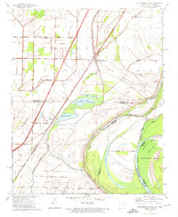
1970 Map of Frenchmans Bayou
USGS Topo · Published 1974About this map
The St Louis-San Francisco railroad and Interstate 40 parallel each other as they strike through the alluvial bottomlands of the Mississippi River valley. This landscape is defined by its complex hydrology, where the St Francis Levee protects agricultural tracts from the shifting waters of the Barney (Old River) Chute and Brandywine Chute. The boundary between Arkansas and Tennessee winds through the center of the river channel, creating isolated landmasses like Centennial Island and Brandywine Island. Small settlements such as Frenchmans Bayou, Meneshea, and Lambethville are connected by a network of drainage canals, including Ditch No 1 and Ditch No 11, which transformed these wetlands for cultivation. Local life is centered around community landmarks like St Pauls Ch and the Shawnee Sch, while the river remains an active thoroughfare evidenced by Happy Valley Landing.
Find a feature on this map
44 named features on this map. Tap any name to fly to it.
Don’t see what you’re looking for? This feature index may not catch every label — zoom into the map to look around manually.
Map Details
Editions of this 1970 Frenchmans Bayou Map
2 editions found
Other maps of this area

1931 · Jericho
USGS Topo · 1:62,500

1939 · Jericho
USGS Topo · 1:62,500

1939 · Evadale
USGS Topo · 1:62,500

1940 · Deckerville
USGS Topo · 1:62,500

1941 · Marked Tree
USGS Topo · 1:62,500

1952 · Jericho
USGS Topo · 1:62,500

1953 · Memphis
USGS Topo · 1:250,000

1956 · Evadale
USGS Topo · 1:62,500

1956 · Marked Tree
USGS Topo · 1:62,500

1956 · Memphis
USGS Topo · 1:250,000