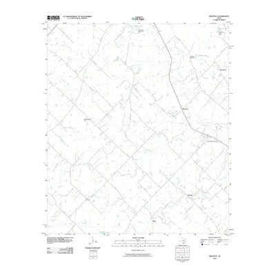
2010 Map of Frenstat
USGS Topo · Published 2010About this map
Frenstat serves as a central hub for this rural Burleson County landscape, characterized by a complex network of creeks and small, private reservoirs. The drainage patterns of Second Davidson Creek, Brushy Creek, and Little Big Creek reveal a terrain heavily utilized for agricultural stock ponds and water management, evidenced by named impoundments like Schumacher Lake, Matcek Lake, and Glover Lake.
Find a feature on this map
64 named features on this map. Tap any name to fly to it.
Don’t see what you’re looking for? This feature index may not catch every label — zoom into the map to look around manually.
Map Details
Editions of this 2010 Frenstat Map
This is the sole edition of this map. No revisions or reprints were ever made.
Other maps of this area

1919 · Dime Box
USGS Topo · 1:62,500

1954 · Austin
USGS Topo · 1:250,000

1956 · Caldwell
USGS Topo · 1:62,500

1956 · Milano
USGS Topo · 1:62,500

1956 · Somerville
USGS Topo · 1:62,500

1959 · Flag Pond
USGS Topo · 1:24,000

1959 · Somerville
USGS Topo · 1:24,000
1959 · Dime Box
USGS Topo · 1:24,000

1960 · Lyons
USGS Topo · 1:24,000
1960 · Frenstat
USGS Topo · 1:24,000