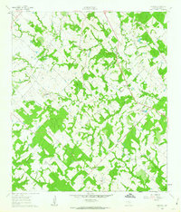
1960 Map of Frenstat
USGS Topo · Published 1963About this map
Frenstat and Harmony anchor this rural Burleson County landscape as it appeared in the early 1960s, a period defined by small-scale cattle ranching and field agriculture. The terrain is intricately drained by several waterways, most notably Davidson Creek and its tributary, Second Davidson Creek, which carve through the undulating hills near Mockingbird Hill. The industrial and transport footprint of the era is evident in the intersection of the Southern Pacific and Gulf Colorado and Santa Fe railroads, which facilitated the movement of local goods and services. Local history is preserved at the Beaird Cem, while the presence of scattered Gravel Pits and the winding Pin Oak Road reflect the local economy and infrastructure during this mid-century transition.
Find a feature on this map
20 named features on this map. Tap any name to fly to it.
Don’t see what you’re looking for? This feature index may not catch every label — zoom into the map to look around manually.
Map Details
Editions of this 1960 Frenstat Map
2 editions found
Other maps of this area

1919 · Dime Box
USGS Topo · 1:62,500

1954 · Austin
USGS Topo · 1:250,000

1956 · Caldwell
USGS Topo · 1:62,500

1956 · Milano
USGS Topo · 1:62,500

1956 · Somerville
USGS Topo · 1:62,500

1959 · Flag Pond
USGS Topo · 1:24,000

1959 · Somerville
USGS Topo · 1:24,000
1959 · Dime Box
USGS Topo · 1:24,000

1960 · Lyons
USGS Topo · 1:24,000
1960 · Deanville
USGS Topo · 1:24,000