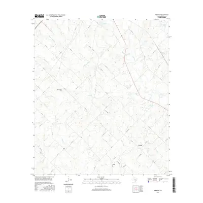
2016 Map of Frenstat
USGS Topo · Published 2016About this map
Frenstat and the rural communities of eastern Burleson County are defined by a network of creeks and small private lakes that drain the rolling landscape. This area, deeply rooted in Texas agricultural history, centers on the crossroads at Frenstat and the nearby settlement of Birch. The topography is shaped by the winding courses of Second Davidson Cr, Brushy Cr, and Birch Cr, which feed into several named water bodies including Sanders Lake and Schumacher Lake. For those researching local family history, Beaird Cem is a significant landmark situated west of the main settlements. The terrain rises to notable points like Mockingbird Hill, while the northwestern corner is clipped by the Presidential Corridor-W, reflecting the modern transit infrastructure that overlays the older grid of county roads such as Co RD 100 and Co RD 122.
Find a feature on this map
66 named features on this map. Tap any name to fly to it.
Don’t see what you’re looking for? This feature index may not catch every label — zoom into the map to look around manually.
Map Details
Editions of this 2016 Frenstat Map
This is the sole edition of this map. No revisions or reprints were ever made.
Other maps of this area

1919 · Dime Box
USGS Topo · 1:62,500

1954 · Austin
USGS Topo · 1:250,000

1956 · Caldwell
USGS Topo · 1:62,500

1956 · Milano
USGS Topo · 1:62,500

1956 · Somerville
USGS Topo · 1:62,500

1959 · Flag Pond
USGS Topo · 1:24,000

1959 · Somerville
USGS Topo · 1:24,000
1959 · Dime Box
USGS Topo · 1:24,000

1960 · Lyons
USGS Topo · 1:24,000
1960 · Frenstat
USGS Topo · 1:24,000