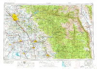
1962 Map of Fresno
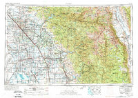
USGS Topo · Published 1974About this map
The San Joaquin Valley meets the high peaks of the Sierra Nevada in this detailed overview of central California. Highlighting the expansion of the Central Valley's agricultural heartland, the map reveals an extensive network of irrigation canals like the Gould Canal and Central Canal, which supported the growing communities of Fresno, Visalia, and Hanford. This era marks the prominence of the Lemoore Naval Air Station and the established campus of Fresno State College. To the east, the landscape rises dramatically through the Sierra National Forest to the summits of Mt Whitney and Mt Williamson. The mapping of the Tulare Lake Bed and various reservoirs like Pine Flat Lake and Wishon Reservoir documents the mid-century water management efforts that fundamentally reshaped this region's hydrology and land use.
Find a feature on this map
264 named features on this map. Tap any name to fly to it.
Don’t see what you’re looking for? This feature index may not catch every label — zoom into the map to look around manually.
Map Details
Editions of this 1962 Fresno Map
3 editions found

Other maps of this area

1903 · Tehipite
USGS Topo · 1:125,000

1904 · Kaiser
USGS Topo · 1:125,000

1904 · Kaweah
USGS Topo · 1:125,000

1905 · Tehipite
USGS Topo · 1:125,000

1905 · Olancha
USGS Topo · 1:125,000

1905 · Fairview
USGS Topo · 1:24,000

1906 · Kernville
USGS Topo · 1:125,000

1907 · Olancha
USGS Topo · 1:125,000

1907 · Mt. Whitney
USGS Topo · 1:125,000

1908 · Lida
USGS Topo · 1:250,000