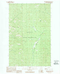
1989 Map of Friedlander Meadows
USGS Topo · Published 1989About this map
The Colville Indian Reservation defines this landscape in Ferry County, where the high ridges and deep drainages of the Sanpoil River watershed meet. Mapping in the late 1980s reveals a terrain marked by early-stage resource exploration, noted by several instances of a Mine Prospect and a Mine Shaft located near the headwaters of Silver Creek. These features point to a legacy of prospecting in the Okanogan Highlands, where miners sought precious metals across rugged divides like Watson Ridge and Whitestone Ridge. The interior is bisected by the lush Friedlander Meadows, a significant riparian corridor fed by the South Fork Ninemile Creek. This environment supported seasonal grazing and traditional land use on reservation lands, well away from major settlements. The hydrological network is dense, with named drainages such as John Tom Creek and Sclome Meadow Creek carving through the slopes of Sclome Mountain.
Find a feature on this map
16 named features on this map. Tap any name to fly to it.
Don’t see what you’re looking for? This feature index may not catch every label — zoom into the map to look around manually.
Map Details
Editions of this 1989 Friedlander Meadows Map
2 editions found
Other maps of this area

1948 · Wilbur
USGS Topo · 1:62,500

1948 · Wilmont Creek
USGS Topo · 1:62,500

1948 · Lincoln
USGS Topo · 1:62,500

1950 · Lincoln
USGS Topo · 1:62,500

1950 · Wilmont Creek
USGS Topo · 1:62,500

1950 · Wilbur
USGS Topo · 1:62,500

1952 · Keller
USGS Topo · 1:62,500

1953 · Ritzville
USGS Topo · 1:250,000

1954 · Okanogan
USGS Topo · 1:250,000

1956 · Wilmont Creek
USGS Topo · 1:62,500