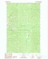
1989 Map of Friedlander Meadows
USGS Topo · Published 1994About this map
The Colville Indian Reservation occupies a significant portion of this landscape in Ferry County, defined by its high ridges and drainages during the late twentieth century. Centered on Friedlander Meadows, the terrain transitions between prominent landmarks like Sclome Mountain and Watson Ridge. This area is heavily dissected by watercourses including Olds Creek, Copper Creek, and Silver Creek, which flow through the upland territory. A small Prospect site north of John Tom Creek suggests localized mineral exploration in this timbered region. The cartography provides a clear look at the topographic character and drainage patterns of the Whitestone Ridge area before subsequent decades of land use.
Find a feature on this map
14 named features on this map. Tap any name to fly to it.
Don’t see what you’re looking for? This feature index may not catch every label — zoom into the map to look around manually.
Map Details
Editions of this 1989 Friedlander Meadows Map
2 editions found
Other maps of this area

1948 · Wilbur
USGS Topo · 1:62,500

1948 · Wilmont Creek
USGS Topo · 1:62,500

1948 · Lincoln
USGS Topo · 1:62,500

1950 · Lincoln
USGS Topo · 1:62,500

1950 · Wilmont Creek
USGS Topo · 1:62,500

1950 · Wilbur
USGS Topo · 1:62,500

1952 · Keller
USGS Topo · 1:62,500

1953 · Ritzville
USGS Topo · 1:250,000

1954 · Okanogan
USGS Topo · 1:250,000

1956 · Wilmont Creek
USGS Topo · 1:62,500