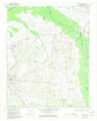
1965 Map of Friendship
USGS Topo · Published 1981About this map
The lowlands of West Tennessee are defined here by the winding courses of the North Fork Deer River and Middle Fork Deer River, which converge near the Dyer, Crockett, and Gibson county lines. This 1965 landscape shows a network of rural settlements and rural churches connected by historic thoroughfares like Eaton Road and Stokes Road. The presence of an Old Railroad Grade running near Tigrett and Little Pond Creek points to the area's earlier transport history, while the topography remains relatively flat, marked only by subtle rises like the Bluff overlooking the river bottomlands. Small community centers such as Friendship, Eaton, and Stokes are interspersed with local landmarks like Mt Zion Ch and Bethesda Ch, reflecting a deeply established agricultural and spiritual fabric across the county boundaries.
Find a feature on this map
35 named features on this map. Tap any name to fly to it.
Don’t see what you’re looking for? This feature index may not catch every label — zoom into the map to look around manually.
Map Details
Editions of this 1965 Friendship Map
2 editions found
Other maps of this area

1939 · Dyersburg
USGS Topo · 1:62,500

1939 · Halls
USGS Topo · 1:62,500

1952 · Bonicord
USGS Topo · 1:24,000

1952 · Newbern
USGS Topo · 1:24,000

1952 · Chestnut Bluff
USGS Topo · 1:24,000

1956 · Dyersburg
USGS Topo · 1:250,000

1956 · Blytheville
USGS Topo · 1:250,000

1959 · Blytheville
USGS Topo · 1:250,000

1961 · Halls
USGS Topo · 1:62,500
1961 · Dyersburg
USGS Topo · 1:62,500