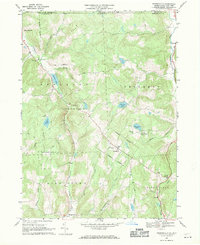
1967 Map of Friendsville
USGS Topo · Published 1971About this map
St Francis Cem and St Thomas Cem anchor the rural landscape of this northern Pennsylvania border region in the late 1960s. The village of Friendsville sits at a crossroads near the center of the sheet, surrounded by several smaller rural clusters including Choconut and Middletown Center. This terrain is defined by the headwaters of numerous southward-draining streams, most notably Wyalusing Creek and its various branches, which slice through the upland hills.
Find a feature on this map
44 named features on this map. Tap any name to fly to it.
Don’t see what you’re looking for? This feature index may not catch every label — zoom into the map to look around manually.
Map Details
Editions of this 1967 Friendsville Map
Other maps of this area

1901 · Apalachin
USGS Topo · 1:62,500

1904 · Binghamton
USGS Topo · 1:62,500

1904 · Apalachin
USGS Topo · 1:62,500

1906 · Catatonk
USGS Topo · 1:125,000

1935 · Binghamton West
USGS Topo · 1:24,000

1942 · Binghamton West
USGS Topo · 1:31,680

1943 · Montrose
USGS Topo · 1:62,500

1943 · Le Raysville
USGS Topo · 1:62,500

1945 · Montrose
USGS Topo · 1:62,500

1945 · Le Raysville
USGS Topo · 1:62,500