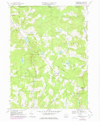
1967 Map of Friendsville
USGS Topo · Published 1978About this map
Friendsville stands at the center of this rural Susquehanna County landscape, where the 1960s agricultural character is preserved alongside extensive recreational and state-managed lands. The area is defined by its deep Catholic roots and community life, evidenced by the cluster of St Francis Ch and the neighboring St Francis Cem. To the north, the terrain transitions into the Choconut valley, where Choconut Lake and Camp Choconut suggest a long-standing tradition of seasonal residency and youth camps, a pattern mirrored at Carmalt Lake with Camp Arrowhead.
Find a feature on this map
44 named features on this map. Tap any name to fly to it.
Don’t see what you’re looking for? This feature index may not catch every label — zoom into the map to look around manually.
Map Details
Editions of this 1967 Friendsville Map
Other maps of this area

1901 · Apalachin
USGS Topo · 1:62,500

1904 · Binghamton
USGS Topo · 1:62,500

1904 · Apalachin
USGS Topo · 1:62,500

1906 · Catatonk
USGS Topo · 1:125,000

1935 · Binghamton West
USGS Topo · 1:24,000

1942 · Binghamton West
USGS Topo · 1:31,680

1943 · Montrose
USGS Topo · 1:62,500

1943 · Le Raysville
USGS Topo · 1:62,500

1945 · Montrose
USGS Topo · 1:62,500

1945 · Le Raysville
USGS Topo · 1:62,500