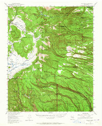
1953 Map of Frijoles
USGS Topo · Published 1965About this map
The Pajarito Plateau and the southern Jemez Mountains are documented here during a mid-century period of transition. The map captures remnants of earlier settlement patterns in the southwest, specifically designating Bland (Ghost Town) and Pines (Ghost Town) as former communities that had already faded into history by the 1950s. Agricultural and pastoral life is still visible through the inclusion of the Twin Rock Ranch and several discontinued homesteads like the Evans-Griffin Place and Bruce Place.
Find a feature on this map
22 named features on this map. Tap any name to fly to it.
Don’t see what you’re looking for? This feature index may not catch every label — zoom into the map to look around manually.
Map Details
Editions of this 1953 Frijoles Map
Other maps of this area

1890 · Jemes
USGS Topo · 1:125,000

1892 · Jemes
USGS Topo · 1:125,000

1892 · Santa Clara
USGS Topo · 1:125,000

1909 · Gallina
USGS Topo · 1:125,000

1918 · Abiquiu
USGS Topo · 1:125,000

1937 · Jemez Springs
USGS Topo · 1:48,000

1943 · Jemez
USGS Topo · 1:62,500

1944 · Jemez Springs
USGS Topo · 1:62,500

1952 · White Rock
USGS Topo · 1:24,000

1952 · Valle Toledo
USGS Topo · 1:24,000