
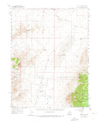
1960 Map of Frisco Peak
USGS Topo · Published 1962About this map
Wah Wah Valley dominates the center of this terrain, characterized by a vast Hardpan and several seasonal water catchments like East Hardpan Reservoir. The landscape transitions from the open valley floor to the high elevations of the Wah Wah Mountains and the Gray Hills, where human activity is marked by remote infrastructure. Evidence of early Utah mining and ranching is scattered throughout the canyons, including the Indian Queen Mine and the specialized Two Rock Charcoal Kilns near Spring Canyon.
Find a feature on this map
38 named features on this map. Tap any name to fly to it.
Don’t see what you’re looking for? This feature index may not catch every label — zoom into the map to look around manually.
Map Details
Editions of this 1960 Frisco Peak Map
2 editions found
Other maps of this area

1953 · Richfield
USGS Topo · 1:250,000

1958 · Richfield
USGS Topo · 1:250,000

1958 · Milford
USGS Topo · 1:62,500

1959 · Frisco
USGS Topo · 1:62,500

1960 · Wah Wah Summit
USGS Topo · 1:62,500

1960 · Beaver Lake Mts.
USGS Topo · 1:62,500

1960 · Crystal Peak
USGS Topo · 1:62,500

1960 · The Barn
USGS Topo · 1:62,500

1971 · Sewing Machine Pass
USGS Topo · 1:24,000
1972 · Sevier Lake SW
USGS Topo · 1:24,000