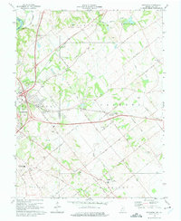
1974 Map of Fritchton
USGS Topo · Published 1975About this map
The Wabash River meanders along the western edge of this landscape, marking the boundary between Indiana and Illinois. This mid-1970s record of Knox County reveals a transition from the eastern outskirts of Vincennes into a rural landscape defined by drainage patterns like Kessinger Ditch and Snapp Creek. The settlement of Fritchton serves as a central hub, flanked by institutional landmarks such as St Vincents Orphanage and Hillcrest School.
Find a feature on this map
44 named features on this map. Tap any name to fly to it.
Don’t see what you’re looking for? This feature index may not catch every label — zoom into the map to look around manually.
Map Details
Editions of this 1974 Fritchton Map
3 editions found
Other maps of this area

1915 · Vincennes
USGS Topo · 1:62,500

1917 · Birds
USGS Topo · 1:62,500

1942 · Fritchton
USGS Topo · 1:24,000

1942 · Birds
USGS Topo · 1:62,500

1943 · Oaktown
USGS Topo · 1:24,000

1943 · Bicknell
USGS Topo · 1:24,000

1944 · Fritchton
USGS Topo · 1:24,000

1944 · Monroe City
USGS Topo · 1:24,000

1944 · Wheatland
USGS Topo · 1:24,000

1944 · Iona
USGS Topo · 1:24,000