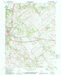
1974 Map of Fritchton
USGS Topo · Published 1988About this map
The Wabash River serves as the western boundary for this portion of Knox County, Indiana, and Lawrence County, Illinois. The landscape transitions from the river's edge toward the eastern uplands of Washington and Palmyra townships. The map documents an area defined by rural community hubs and agrarian industry, notably the village of Fritchton and the crossroads at Verne. Significant land use changes are visible through the marking of a Reclaimed Strip Mine and associated Reclaimed tailings, indicating the evolution of the local economy from extraction back to managed terrain.
Find a feature on this map
53 named features on this map. Tap any name to fly to it.
Don’t see what you’re looking for? This feature index may not catch every label — zoom into the map to look around manually.
Map Details
Editions of this 1974 Fritchton Map
3 editions found
Other maps of this area

1915 · Vincennes
USGS Topo · 1:62,500

1917 · Birds
USGS Topo · 1:62,500

1942 · Fritchton
USGS Topo · 1:24,000

1942 · Birds
USGS Topo · 1:62,500

1943 · Oaktown
USGS Topo · 1:24,000

1943 · Bicknell
USGS Topo · 1:24,000

1944 · Fritchton
USGS Topo · 1:24,000

1944 · Monroe City
USGS Topo · 1:24,000

1944 · Wheatland
USGS Topo · 1:24,000

1944 · Iona
USGS Topo · 1:24,000