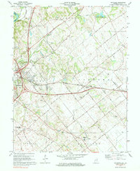
1974 Map of Fritchton
USGS Topo · Published 1984About this map
Vincennes sits on the western edge of this landscape, where the Wabash River serves as the state boundary between Indiana and Illinois. Moving east from the river, the terrain transitions into the agricultural and wooded uplands of Knox County. The rural character of the mid-1970s is evident in the cluster of institutions and small communities, such as the St Vincents Orphanage and the settlement of Fritchton. The map captures a period when transportation was still defined by the heavy rail lines of the Baltimore and Ohio and the Penn Central, which cut diagonally across the townships of Palmyra and Washington. Several historic congregations and burial grounds, including the Upper Indiana Ch and Root Cem, are scattered throughout the countryside, providing a detailed record for genealogists. Resource extraction is also present, indicated by a quarry and several tailings piles near Pond Creek.
Find a feature on this map
44 named features on this map. Tap any name to fly to it.
Don’t see what you’re looking for? This feature index may not catch every label — zoom into the map to look around manually.
Map Details
Editions of this 1974 Fritchton Map
3 editions found
Other maps of this area

1915 · Vincennes
USGS Topo · 1:62,500

1917 · Birds
USGS Topo · 1:62,500

1942 · Fritchton
USGS Topo · 1:24,000

1942 · Birds
USGS Topo · 1:62,500

1943 · Oaktown
USGS Topo · 1:24,000

1943 · Bicknell
USGS Topo · 1:24,000

1944 · Fritchton
USGS Topo · 1:24,000

1944 · Monroe City
USGS Topo · 1:24,000

1944 · Wheatland
USGS Topo · 1:24,000

1944 · Iona
USGS Topo · 1:24,000