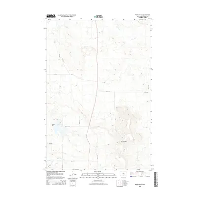
2014 Map of Froelich Dam
USGS Topo · Published 2014About this map
Porcupine Hills dominate the southeastern landscape of this Sioux County quadrangle, rising above the surrounding prairie as a series of prominent ridges and drainages. The Froelich Dam serves as a primary water management feature in the west, creating a significant catchment area that contrasts with the arid character of the neighboring terrain. This 2014 survey documents a region defined by its wide, open spaces and a network of tribal and local roads, such as Bia-7 and 87th St SW, which trace the section lines typical of the Great Plains. The hydrology is centered on Porcupine Cr, which meanders through the northern and eastern portions of the map, while Little Heart Flats provides a rare level expanse amidst the rising elevation. The layout illustrates the sparse settlement patterns of the Fort Yates District, where geography and elevation dictate the paths of rural infrastructure.
Find a feature on this map
18 named features on this map. Tap any name to fly to it.
Don’t see what you’re looking for? This feature index may not catch every label — zoom into the map to look around manually.
Map Details
Editions of this 2014 Froelich Dam Map
This is the sole edition of this map. No revisions or reprints were ever made.
Other maps of this area

1954 · Bismarck
USGS Topo · 1:250,000

1958 · Bismarck
USGS Topo · 1:250,000

1971 · Barren Butte
USGS Topo · 1:24,000

1971 · Half Timber Butte
USGS Topo · 1:24,000

1971 · Froelich Dam
USGS Topo · 1:24,000

1971 · Solen SW
USGS Topo · 1:24,000

1971 · Porcupine
USGS Topo · 1:24,000

1971 · Timmer
USGS Topo · 1:24,000
1971 · Selfridge SE
USGS Topo · 1:24,000

1971 · Selfridge
USGS Topo · 1:24,000