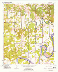
1951 Map of Frogville
USGS Topo · Published 1977About this map
Frogville serves as the small hub of this rural borderland, where the Kiamichi River winds through the Wilson and Everidge regions toward its confluence with the Red River. The landscape is a network of mid-century rural education and faith, evidenced by numerous school sites like Oma Sch and Lake View Sch, alongside houses of worship such as St Johns Ch. Of particular note for genealogists is the high density of burial grounds, including Everidge Cem, Spring Hill Cem, and Missionary Cem. The meandering waterways define the state line, featuring the prominent Everidge Lake Cut-off and the isolated Bowman Island, reflecting the shifting nature of the river-based boundary between Oklahoma and Texas.
Find a feature on this map
26 named features on this map. Tap any name to fly to it.
Don’t see what you’re looking for? This feature index may not catch every label — zoom into the map to look around manually.
Map Details
Editions of this 1951 Frogville Map
3 editions found
Other maps of this area

1901 · Alikchi
USGS Topo · 1:125,000

1950 · Mcalester
USGS Topo · 1:250,000

1951 · Slate Shoals
USGS Topo · 1:24,000

1951 · Frogville
USGS Topo · 1:24,000

1951 · Shoals
USGS Topo · 1:24,000

1951 · Kiomatia
USGS Topo · 1:24,000

1951 · Woodland
USGS Topo · 1:24,000

1951 · Manchester
USGS Topo · 1:24,000

1953 · Texarkana
USGS Topo · 1:250,000

1956 · Texarkana
USGS Topo · 1:250,000