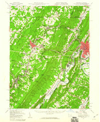
1950 Map of Frostburg
USGS Topo · Published 1960About this map
Savage Mountain and the high ridges of the Alleghenies dominate this mid-century landscape, where industrial coal mining and major transportation arteries converge. The National Pike winds through the hills, connecting established settlements like Frostburg and Midland with the busy rail corridors of the Baltimore and Ohio Railroad and the Western Maryland Railway. Evidence of the region’s extractive economy is visible at the Borden Shaft and various strip mines that mark the terrain between Georges Creek and Jennings Run.
Find a feature on this map
166 named features on this map. Tap any name to fly to it.
Don’t see what you’re looking for? This feature index may not catch every label — zoom into the map to look around manually.
Map Details
Editions of this 1950 Frostburg Map
3 editions found
Other maps of this area

1891 · Romney
USGS Topo · 1:125,000

1895 · Piedmont
USGS Topo · 1:125,000

1898 · Frostburg
USGS Topo · 1:62,500

1899 · Flintstone
USGS Topo · 1:62,500

1899 · Grantsville
USGS Topo · 1:62,500

1900 · Flintstone
USGS Topo · 1:62,500

1901 · Frostburg
USGS Topo · 1:62,500

1904 · Grantsville
USGS Topo · 1:62,500

1908 · Frostburg
USGS Topo · 1:62,500

1919 · Elk Garden
USGS Topo · 1:48,000