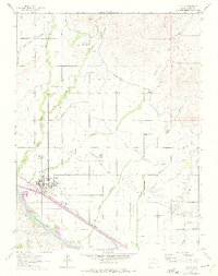
1962 Map of Fruita
USGS Topo · Published 1975About this map
The town of Fruita sits as a central hub on the northern bank of the Colorado River, where the high desert meets the valley's intricate irrigation network. This survey, updated with 1973 revisions, reveals an agricultural landscape sustained by the Government Highline Canal and the Grand Valley Canal, which carve distinct paths through the arid terrain. The Denver and Rio Grande Western Railroad runs parallel to the river, connecting the main settlement to the community at Rhone. Local community life is anchored by the Sacred Heart Ch, the High Sch, and rural hubs like the Star Community Center. To the north and west, numerous drainages such as Big Salt Wash and Reed Wash descend from the higher elevations, while the southern edge is marked by the entrance to Kodels Canyon, illustrating the transition from managed farmland to natural desert features.
Find a feature on this map
28 named features on this map. Tap any name to fly to it.
Don’t see what you’re looking for? This feature index may not catch every label — zoom into the map to look around manually.
Map Details
Editions of this 1962 Fruita Map
4 editions found
Other maps of this area

1934 · Colorado National Monument
USGS Topo · 1:24,000

1956 · Grand Junction
USGS Topo · 1:250,000

1959 · Grand Junction
USGS Topo · 1:250,000

1960 · Grand Junction
USGS Topo · 1:250,000

1962 · Grand Junction
USGS Topo · 1:250,000

1962 · Fruita
USGS Topo · 1:24,000

1962 · Mack
USGS Topo · 1:24,000

1962 · Colorado National Monument
USGS Topo · 1:24,000
1962 · Battleship Rock
USGS Topo · 1:24,000

1962 · Grand Junction
USGS Topo · 1:24,000