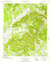
1942 Map of Fruitland
USGS Topo · Published 1957About this map
The boundary between Buncombe Co and Henderson Co cuts through this 1942 landscape, where the Blue Ridge foothills are defined by a complex network of gaps and peaks. The community of Fruitland serves as a local hub near Fruitland Cem, while the industrial and transportation corridor to the west is anchored by the Southern railroad and the Asheville-Hendersonville Airport. This map captures a mid-century period where rural life was punctuated by specialized institutions like the Christ Sch and the Mountain Sanitarium near Hendersonville. A clear pattern of upland settlement is visible, with numerous churches such as Tweed Chapel and Oak Grove Ch nestled in the coves. The presence of Kilns near Shehan suggests small-scale local industry alongside the agricultural valleys of Cane Creek and Clear Creek.
Find a feature on this map
83 named features on this map. Tap any name to fly to it.
Don’t see what you’re looking for? This feature index may not catch every label — zoom into the map to look around manually.
Map Details
Editions of this 1942 Fruitland Map
4 editions found

Other maps of this area

1894 · Asheville
USGS Topo · 1:125,000

1900 · Mount Mitchell
USGS Topo · 1:125,000

1901 · Asheville
USGS Topo · 1:125,000

1902 · Mount Mitchell
USGS Topo · 1:125,000

1905 · Pisgah
USGS Topo · 1:125,000

1906 · Pisgah
USGS Topo · 1:125,000

1907 · Saluda
USGS Topo · 1:125,000

1935 · Horse Shoe
USGS Topo · 1:24,000

1935 · Batcave
USGS Topo · 1:24,000

1935 · Hendersonville
USGS Topo · 1:24,000