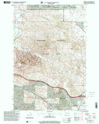
1997 Map of Fryburg NW
USGS Topo · Published 2001About this map
The badlands of western North Dakota dominate this late 20th-century landscape, where the Theodore Roosevelt National Park meets the Little Missouri National Grassland. The terrain is marked by distinctive geological features such as the Burning Coal Vein and the Painted Canyon Overlook, illustrating the unique erosion-carved topography of the region. This survey also records the industrial footprint of the Fryburg Oil Field in the southeast corner, contrasting preservation land with resource extraction. Water sources are critical in this environment, represented by named features like Boicourt Spring, Sheep Butte Spring, and the Mike Auney Flowing Well. Landmarks such as Buck Hill and Wind Canyon provide points of reference for those navigating the network of 4WD trails and the Beef Corral Bottom along the Missouri River.
Find a feature on this map
26 named features on this map. Tap any name to fly to it.
Don’t see what you’re looking for? This feature index may not catch every label — zoom into the map to look around manually.
Map Details
Editions of this 1997 Fryburg NW Map
This is the sole edition of this map. No revisions or reprints were ever made.
Other maps of this area

1953 · Dickinson
USGS Topo · 1:250,000

1953 · Watford City
USGS Topo · 1:250,000

1957 · Dickinson
USGS Topo · 1:250,000

1957 · Watford City
USGS Topo · 1:250,000

1962 · Tracy Mountain
USGS Topo · 1:24,000

1962 · Fryburg NE
USGS Topo · 1:24,000

1962 · Fryburg
USGS Topo · 1:24,000

1962 · Fryburg NW
USGS Topo · 1:24,000

1963 · Gorham SW
USGS Topo · 1:24,000

1963 · Gorham SE
USGS Topo · 1:24,000