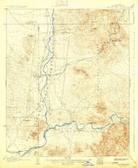
1906 Map of Ft. McDowell
USGS Topo · Published 1931About this map
The confluence of the Salt River and the Verde River serves as the central focal point of this survey, illustrating the early 20th-century water infrastructure and ranching landscape of Maricopa County. The Fort Mc Dowell Indian Reservation occupies the river valley, centered on Fort Mc Dowell Mc Dowell P O and extending through the rugged mesa country. Notable for local historians and genealogists are the numerous pioneer family holdings scattered across the terrain, including Ashers Ranch, Adams' Ranch, and Stewarts Ranch.
Find a feature on this map
35 named features on this map. Tap any name to fly to it.
Don’t see what you’re looking for? This feature index may not catch every label — zoom into the map to look around manually.
Map Details
Editions of this 1906 Ft. McDowell Map
3 editions found
Other maps of this area

1900 · Florence
USGS Topo · 1:125,000

1902 · Florence
USGS Topo · 1:125,000

1904 · Camelback
USGS Topo · 1:62,500

1904 · Desert Well
USGS Topo · 1:62,500

1904 · Ft. McDowell
USGS Topo · 1:62,500

1906 · Camelsback
USGS Topo · 1:62,500

1906 · Ft. McDowell
USGS Topo · 1:62,500

1906 · Desert Well
USGS Topo · 1:62,500

1907 · Roosevelt
USGS Topo · 1:125,000

1909 · Four Peaks
USGS Topo · 1:125,000