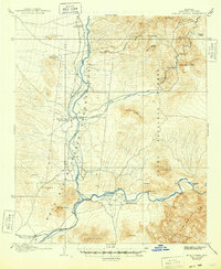
1906 Map of Ft. McDowell
USGS Topo · Published 1948About this map
Fort Mc Dowell Indian Reservation anchors this early 20th-century landscape where the Verde River meets the Salt River. The map, surveyed in 1904, documents a period of transition in Central Arizona's water management, notably featuring the Granite Reef Dam and the intake for the Arizona Canal. This hydraulic infrastructure is surrounded by a network of scattered ranching outposts, including Ashers Ranch, Otero's Ranch, and Adams' Ranch, indicating the localized agrarian economy prior to the mid-century urbanization of Maricopa County.
Find a feature on this map
37 named features on this map. Tap any name to fly to it.
Don’t see what you’re looking for? This feature index may not catch every label — zoom into the map to look around manually.
Map Details
Editions of this 1906 Ft. McDowell Map
3 editions found
Other maps of this area

1900 · Florence
USGS Topo · 1:125,000

1902 · Florence
USGS Topo · 1:125,000

1904 · Camelback
USGS Topo · 1:62,500

1904 · Desert Well
USGS Topo · 1:62,500

1904 · Ft. McDowell
USGS Topo · 1:62,500

1906 · Camelsback
USGS Topo · 1:62,500

1906 · Ft. McDowell
USGS Topo · 1:62,500

1906 · Desert Well
USGS Topo · 1:62,500

1907 · Roosevelt
USGS Topo · 1:125,000

1909 · Four Peaks
USGS Topo · 1:125,000