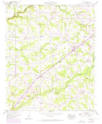
1946 Map of Fyffe
USGS Topo · Published 1972About this map
Sand Mountain dominates this portion of the Panhandle region, where the plateau landscape is defined by a dense network of upland churches and intersecting rural roads. Surveyed in 1946 and updated with 1970 aerial data, the map reveals the mid-century development of Fyffe and the growing boundary of Rainsville to the northeast. The agricultural character of the era is evident in the numerous crossroads settlements like Moores Crossroads and Gibson Crossroads, which served as local focal points for the surrounding farmsteads.
Find a feature on this map
72 named features on this map. Tap any name to fly to it.
Don’t see what you’re looking for? This feature index may not catch every label — zoom into the map to look around manually.
Map Details
Editions of this 1946 Fyffe Map
2 editions found
Other maps of this area

1885 · Gadsden
USGS Topo · 1:125,000

1886 · Stevenson
USGS Topo · 1:125,000

1888 · Gadsden
USGS Topo · 1:125,000

1888 · Scottsboro
USGS Topo · 1:125,000

1892 · Scottsboro
USGS Topo · 1:125,000

1892 · Stevenson
USGS Topo · 1:125,000

1892 · Gadsden
USGS Topo · 1:125,000

1893 · Fort Payne
USGS Topo · 1:125,000

1895 · Stevenson
USGS Topo · 1:125,000

1895 · Gadsden
USGS Topo · 1:125,000