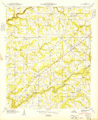
1949 Map of Fyffe
USGS Topo · Published 1949About this map
Sand Mountain dominates the landscape of this 1940s Alabama survey, defining a rural plateau where agriculture and faith anchored the local community. The settlement of Fyffe serves as a central hub along the highway, while the surrounding countryside is densely populated with small landmarks vital to genealogists and local historians. Family names and community centers are everywhere, from the Warren Cem Graveyard to a network of local schools like Antioch Sch and McKestee Sch. The rugged drainage of South Sauty Creek and Town Creek carves through the sandstone, creating crossings such as the Lebanon Ford Bridge and Lawson Ford. Numerous country churches, including Old Corinth Ch, Beulah Ch, and Nazareth Ch, illustrate the social fabric of De Kalb County before mid-century modernization altered these traditional settlement patterns.
Find a feature on this map
59 named features on this map. Tap any name to fly to it.
Don’t see what you’re looking for? This feature index may not catch every label — zoom into the map to look around manually.
Map Details
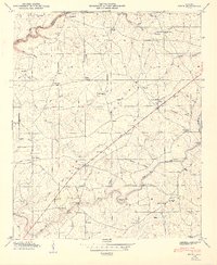
Editions of this 1949 Fyffe Map
2 editions found
Other maps of this area

1885 · Gadsden
USGS Topo · 1:125,000

1886 · Stevenson
USGS Topo · 1:125,000

1888 · Gadsden
USGS Topo · 1:125,000

1888 · Scottsboro
USGS Topo · 1:125,000

1892 · Scottsboro
USGS Topo · 1:125,000

1892 · Stevenson
USGS Topo · 1:125,000

1892 · Gadsden
USGS Topo · 1:125,000

1893 · Fort Payne
USGS Topo · 1:125,000

1895 · Stevenson
USGS Topo · 1:125,000

1895 · Gadsden
USGS Topo · 1:125,000