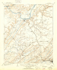
1903 Map of Gadsden
USGS Topo · Published 1950About this map
Guntersville and the winding Tennessee River define the northern reaches of this late 19th-century landscape. Before the massive hydro-electric projects of the 20th century altered the river valley, the waterway was a hub of transit marked by Coal Landing, Lovelace Landing, and ferries serving early settlements like F't Deposit and Warrenton. The central plateau of Sand Mountain is dotted with developing communities such as Albertville, Boaz, and Horton, while the Nashville Chattanooga and St. Louis RR cuts a path through the valley toward the industrial rail junction at Attalla. Genealogists may find value in the specific locations of rural landmarks like Mt Zion church or the numerous gaps through the ridgelines, including Gregory Gap and Sherfield Gap. The geography reveals a complex network of creeks and mountains, including Blount Mountain and Lookout Mountain, that shaped the early settlement patterns of Marshall and Etowah counties.
Find a feature on this map
159 named features on this map. Tap any name to fly to it.
Don’t see what you’re looking for? This feature index may not catch every label — zoom into the map to look around manually.
Map Details
Editions of this 1903 Gadsden Map
4 editions found

Other maps of this area

1885 · Gadsden
USGS Topo · 1:125,000

1886 · Stevenson
USGS Topo · 1:125,000

1888 · Cullman
USGS Topo · 1:125,000

1888 · Gadsden
USGS Topo · 1:125,000

1888 · Scottsboro
USGS Topo · 1:125,000

1888 · Huntsville
USGS Topo · 1:125,000

1889 · Springville
USGS Topo · 1:125,000

1889 · Birmingham
USGS Topo · 1:125,000

1892 · Cullman
USGS Topo · 1:125,000

1892 · Birmingham
USGS Topo · 1:125,000