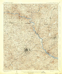
1909 Map of Gaffney
USGS Topo · Published 1937About this map
The Broad River winds through the heart of Cherokee County, defining the early 20th-century landscape of northern South Carolina and the state line border with Cleveland County, North Carolina. This period is marked by a reliance on river crossings and the burgeoning industrial nodes of Gaffney and Blacksburg. The map documents a vanishing era of river transportation, naming several vital crossing points such as Ellis Ferry, Jones Ferry, and Cherokee Ferry, which served the region before modern bridges dominated the corridor.
Find a feature on this map
73 named features on this map. Tap any name to fly to it.
Don’t see what you’re looking for? This feature index may not catch every label — zoom into the map to look around manually.
Map Details
Editions of this 1909 Gaffney Map
4 editions found
Other maps of this area

1906 · Kings Mountain
USGS Topo · 1:62,500

1907 · Sharon
USGS Topo · 1:62,500

1908 · Kings Mountain
USGS Topo · 1:62,500

1909 · Gaffney
USGS Topo · 1:62,500

1909 · Lincolnton
USGS Topo · 1:62,500

1911 · Lincolnton
USGS Topo · 1:62,500

1941 · Spartanburg
USGS Topo · 1:250,000

1947 · Spartanburg
USGS Topo · 1:62,500

1949 · Spartanburg
USGS Topo · 1:62,500

1950 · Shelby
USGS Topo · 1:62,500