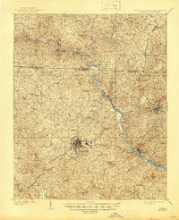
1909 Map of Gaffney
USGS Topo · Published 1945About this map
Gaffney and Blacksburg serve as the primary hubs of this South Carolina landscape, captured just after the turn of the century when the region's economy relied heavily on the Broad River. The river is a focal point of activity, marked by numerous crossings like Jones Ferry, Ellis Ferry, and the Island Ford. Industrial and topographical landmarks such as Gaston Shoals and the Ninety Nine Islands reveal the river's rugged character before significant modern alterations. The Atlanta and Charlotte Air Line provides the essential rail connection through the Piedmont, linking local cotton and textile interests to broader markets. In the surrounding hills, a dense network of country churches including Mt Zion Church and Buffalo Church alongside family-named terrain like Silver Mine Ridge and Draytonville Mtn point to a deeply rooted rural society centered around small settlements and agrarian life.
Find a feature on this map
73 named features on this map. Tap any name to fly to it.
Don’t see what you’re looking for? This feature index may not catch every label — zoom into the map to look around manually.
Map Details
Editions of this 1909 Gaffney Map
4 editions found
Other maps of this area

1906 · Kings Mountain
USGS Topo · 1:62,500

1907 · Sharon
USGS Topo · 1:62,500

1908 · Kings Mountain
USGS Topo · 1:62,500

1909 · Gaffney
USGS Topo · 1:62,500

1909 · Lincolnton
USGS Topo · 1:62,500

1911 · Lincolnton
USGS Topo · 1:62,500

1941 · Spartanburg
USGS Topo · 1:250,000

1947 · Spartanburg
USGS Topo · 1:62,500

1949 · Spartanburg
USGS Topo · 1:62,500

1950 · Shelby
USGS Topo · 1:62,500