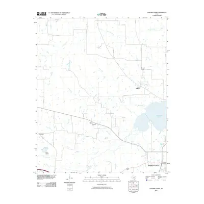
2010 Map of Gafford Chapel
USGS Topo · Published 2010About this map
Sulphur Springs sits at the southern edge of this Hopkins County landscape, where the town's residential expansion meets the rural drainages of the White Oak Creek basin. The area is defined by a dense network of county roads that connect longstanding rural communities such as Pleasant Grove, Good Neighbor, and Overland. In the central portion of the quadrangle, the namesake Gafford Chapel and the surrounding settlement of Gafford anchor a landscape of small farm plots and wooded creek bottoms. To the east, the waters of Lake Sulphur Springs dominate the terrain, serving as a significant local reservoir. The map reveals a complex hydrological system where Blacks Creek, Riley Creek, and Lindley Creek converge toward the larger creek systems, illustrating the transition from open agricultural land to the structured water management systems near the city, including the James R Beck Lake Dam.
Find a feature on this map
49 named features on this map. Tap any name to fly to it.
Don’t see what you’re looking for? This feature index may not catch every label — zoom into the map to look around manually.
Map Details
Editions of this 2010 Gafford Chapel Map
This is the sole edition of this map. No revisions or reprints were ever made.
Other maps of this area

1953 · Texarkana
USGS Topo · 1:250,000

1956 · Texarkana
USGS Topo · 1:250,000

1962 · Miller Grove
USGS Topo · 1:24,000

1962 · Brashear
USGS Topo · 1:24,000

1964 · Cumby
USGS Topo · 1:24,000

1964 · Sulphur Springs
USGS Topo · 1:24,000

1964 · Gafford Chapel
USGS Topo · 1:24,000

1964 · Klondike
USGS Topo · 1:24,000

1964 · Tira
USGS Topo · 1:24,000
1964 · Cooper South
USGS Topo · 1:24,000