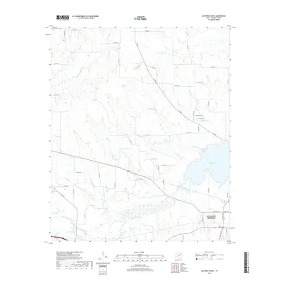
2019 Map of Gafford Chapel
USGS Topo · Published 2019About this map
Gafford Chapel and the outskirts of Sulphur Springs anchor this portion of Hopkins County, where the landscape is defined by the complex drainage of the White Oak Creek basin. The map reveals a transition from the urban grid of the county seat in the southeast to a rural network of county roads and meandering streams. Significant water features such as Lake Sulphur Springs and James R Beck Lake illustrate the area's water management and recreation patterns. The terrain is intricately carved by several named tributaries, including Metcalf Creek, Blacks Creek, and Horse Pen Creek, which flow through the rolling agricultural lands and wetlands. This 2019 survey documents the modern layout of farm-to-market roads like FM 2285 alongside the established community centers that have shaped this north Texas region for generations.
Find a feature on this map
56 named features on this map. Tap any name to fly to it.
Don’t see what you’re looking for? This feature index may not catch every label — zoom into the map to look around manually.
Map Details
Editions of this 2019 Gafford Chapel Map
This is the sole edition of this map. No revisions or reprints were ever made.
Other maps of this area

1953 · Texarkana
USGS Topo · 1:250,000

1956 · Texarkana
USGS Topo · 1:250,000

1962 · Miller Grove
USGS Topo · 1:24,000

1962 · Brashear
USGS Topo · 1:24,000

1964 · Cumby
USGS Topo · 1:24,000

1964 · Sulphur Springs
USGS Topo · 1:24,000

1964 · Gafford Chapel
USGS Topo · 1:24,000

1964 · Klondike
USGS Topo · 1:24,000

1964 · Tira
USGS Topo · 1:24,000
1964 · Cooper South
USGS Topo · 1:24,000