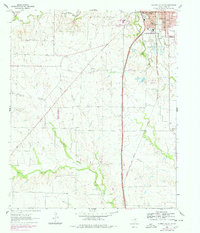
1960 Map of Gainesville South
USGS Topo · Published 1978About this map
The Gainesville city limits expand southward into the rolling prairie of Cooke County in this 1960s study, revealing a community anchored by institutional landmarks like the Lindsay Sanitarium and Mc Murray Sch. Along the southern edge of the city, recreational and public spaces such as Leonard Park, the Zoo, and a Baseball Park border the Elm Fork Trinity River. The landscape beyond the city is defined by the Atchison Topeka and Santa Fe railroad corridor, which runs parallel to the river valley through a network of creeks including Scott Creek, Willow Creek, and Hackley Creek. Rural life centers on several small country congregations and burial grounds, notably Spring Creek Ch and the nearby Spring Creek Cem. The transition from the urban grid of California Street to the scattered Gravel Pits and cattle lands illustrates the mid-century intersection of Texas rail commerce and agriculture.
Find a feature on this map
36 named features on this map. Tap any name to fly to it.
Don’t see what you’re looking for? This feature index may not catch every label — zoom into the map to look around manually.
Map Details
Editions of this 1960 Gainesville South Map
2 editions found
Other maps of this area

1902 · Gainesville
USGS Topo · 1:125,000

1943 · Gainesville
USGS Topo · 1:125,000

1954 · Sherman
USGS Topo · 1:250,000

1958 · Sherman
USGS Topo · 1:250,000

1960 · Callisburg
USGS Topo · 1:24,000

1960 · Gainesville South
USGS Topo · 1:24,000

1960 · Gainesville North
USGS Topo · 1:24,000

1960 · Woodbine
USGS Topo · 1:24,000

1961 · Era
USGS Topo · 1:24,000

1961 · Hood
USGS Topo · 1:24,000