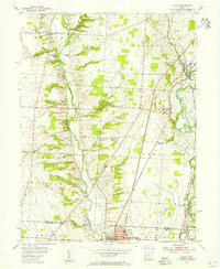
1955 Map of Galena
USGS Topo · Published 1956About this map
Otterbein College and the northern reaches of Westerville anchor the southern edge of this mid-1950s survey of southern Delaware County. The landscape is defined by the nascent Hoover Reservoir along Big Walnut Creek, where the shoreline reaches past Mackstown toward the village of Galena. The map documents a rural Ohio transition, showing long-established settlements like Africa and Cheshire alongside mid-century landmarks like Victory Camp and the Sunbury Golf Course.
Find a feature on this map
38 named features on this map. Tap any name to fly to it.
Don’t see what you’re looking for? This feature index may not catch every label — zoom into the map to look around manually.
Map Details
Editions of this 1955 Galena Map
This is the sole edition of this map. No revisions or reprints were ever made.
Other maps of this area

1901 · Dublin
USGS Topo · 1:62,500

1902 · Westerville
USGS Topo · 1:62,500

1903 · Dublin
USGS Topo · 1:62,500

1904 · Westerville
USGS Topo · 1:62,500

1915 · Marengo
USGS Topo · 1:62,500

1924 · Delaware
USGS Topo · 1:62,500

1925 · Delaware
USGS Topo · 1:62,500

1943 · Marengo
USGS Topo · 1:62,500

1944 · Delaware
USGS Topo · 1:62,500

1950 · Marion
USGS Topo · 1:250,000