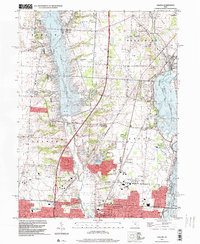
1995 Map of Galena
USGS Topo · Published 1999About this map
The northern expansion of Columbus and the growth of Westerville define this 1995 landscape, where suburban development meets the significant water engineering projects of central Ohio. Large reservoirs dominate the geography, notably the massive Alum Creek Lake and Hoover Reservoir, which flank the central corridor of Genoa and Orange townships. This mapping captures the area as it transitioned from rural farmlands to a connected suburban network, while preserving the footprints of older settlements like Africa and Cheshire.
Find a feature on this map
40 named features on this map. Tap any name to fly to it.
Don’t see what you’re looking for? This feature index may not catch every label — zoom into the map to look around manually.
Map Details
Editions of this 1995 Galena Map
This is the sole edition of this map. No revisions or reprints were ever made.
Other maps of this area

1901 · Dublin
USGS Topo · 1:62,500

1902 · Westerville
USGS Topo · 1:62,500

1903 · Dublin
USGS Topo · 1:62,500

1904 · Westerville
USGS Topo · 1:62,500

1915 · Marengo
USGS Topo · 1:62,500

1924 · Delaware
USGS Topo · 1:62,500

1925 · Delaware
USGS Topo · 1:62,500

1943 · Marengo
USGS Topo · 1:62,500

1944 · Delaware
USGS Topo · 1:62,500

1950 · Marion
USGS Topo · 1:250,000