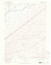
1951 Map of Galien
USGS Topo · Published 1972About this map
The South Platte River corridor in Logan County defines this landscape, where early 1970s updates reveal the complex irrigation infrastructure required for High Plains agriculture. A network of gravity-fed channels, including the Sterling No 1 Ditch, Platte Valley Ditch, and Lone Tree Ditch, diverts water from the river to support the surrounding ranchlands. This heavy reliance on water management is further evidenced by numerous Windmills dotting the terrain, essential for livestock at sites like the Frank Blair Ranch.
Find a feature on this map
12 named features on this map. Tap any name to fly to it.
Don’t see what you’re looking for? This feature index may not catch every label — zoom into the map to look around manually.
Map Details
Editions of this 1951 Galien Map
4 editions found
Other maps of this area

1951 · Reiradon Hill
USGS Topo · 1:24,000

1951 · Sterling South
USGS Topo · 1:24,000

1951 · Sterling North
USGS Topo · 1:24,000

1951 · Galien
USGS Topo · 1:24,000

1951 · Iliff
USGS Topo · 1:24,000

1952 · Padroni
USGS Topo · 1:24,000

1953 · Proctor
USGS Topo · 1:24,000

1954 · Sterling
USGS Topo · 1:250,000

1958 · Sterling
USGS Topo · 1:250,000

1962 · Uhler Ranch
USGS Topo · 1:24,000