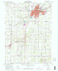
1960 Map of Galion
USGS Topo · Published 1974About this map
The railroad junction at Galion serves as the industrial and commercial anchor of this north-central Ohio landscape during the early 1960s and 1970s. Both the Penn Central and Erie-Lackawanna lines converge here, cutting through a grid of rural farmland defined by the Olentangy River and the Whetstone River. The map captures Galion at a peak of municipal development, showing the Childrens Home, a large Hospital, and numerous education facilities like South Sch and Dawsett Sch.
Find a feature on this map
61 named features on this map. Tap any name to fly to it.
Don’t see what you’re looking for? This feature index may not catch every label — zoom into the map to look around manually.
Map Details
Editions of this 1960 Galion Map
3 editions found
Other maps of this area

1913 · Mount Gilead
USGS Topo · 1:62,500

1915 · Bucyrus
USGS Topo · 1:62,500

1915 · Crestline
USGS Topo · 1:62,500

1915 · Shauck
USGS Topo · 1:62,500

1916 · Mount Gilead
USGS Topo · 1:62,500

1943 · Shauck
USGS Topo · 1:62,500

1943 · Bucyrus
USGS Topo · 1:62,500

1943 · Crestline
USGS Topo · 1:62,500

1943 · Mount Gilead
USGS Topo · 1:62,500

1950 · Marion
USGS Topo · 1:250,000