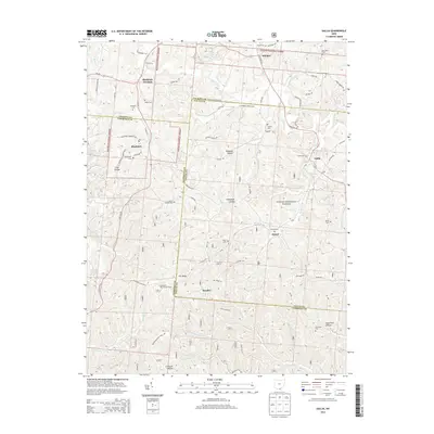
2013 Map of Gallia
USGS Topo · Published 2013About this map
Wayne National Forest land dominates this section of southern Ohio, where the borders of Jackson, Lawrence, and Gallia counties converge among narrow valleys and steep ridges. The map documents a landscape defined by small, dispersed settlements like Blackfork Junction, Kitchen, and Peniel, many of which grew around early industry and crossroads. Notable family and community landmarks are scattered throughout the hills, including Bethel Cem, Sardis Cem, and the Union Baptist Cem. A significant elevation point is marked by the Telegraph Hill Lookout Tower overlooking the intersection of State Rte 93 and Telegraph Hill Rd E. The drainage pattern is complex, with numerous small waterways such as Dirtyface Cr, Cambria Cr, and Black Fork carving through named terrain features like Kokeene Hollow and Pokepatch Hollow. This survey provides a clear view of the rural infrastructure and cemetery locations essential for genealogical research in this tri-county area.
Find a feature on this map
83 named features on this map. Tap any name to fly to it.
Don’t see what you’re looking for? This feature index may not catch every label — zoom into the map to look around manually.
Map Details
Editions of this 2013 Gallia Map
This is the sole edition of this map. No revisions or reprints were ever made.
Other maps of this area

1898 · Ironton
USGS Topo · 1:62,500

1900 · Ironton
USGS Topo · 1:62,500

1906 · Bidwell
USGS Topo · 1:62,500

1906 · Athalia
USGS Topo · 1:62,500

1908 · Bidwell
USGS Topo · 1:62,500

1908 · Athalia
USGS Topo · 1:62,500

1912 · Oak Hill
USGS Topo · 1:62,500

1957 · Huntington
USGS Topo · 1:250,000

1960 · Huntington
USGS Topo · 1:250,000
1961 · Petersburg
USGS Topo · 1:24,000