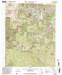
2002 Map of Gallia
USGS Topo · Published 2006About this map
Wayne National Forest dominates this section of the Appalachian foothills at the start of the 21st century, where the boundaries of Jackson, Lawrence, and Gallia Counties meet. The landscape is deeply defined by its industrial history, visible in the numerous claypits, kilns, and strip mines that pock the hillsides around Blackfork. This area served as a critical node for the extraction and processing of local natural resources, supported by the Blackfork Junction rail connection.
Find a feature on this map
51 named features on this map. Tap any name to fly to it.
Don’t see what you’re looking for? This feature index may not catch every label — zoom into the map to look around manually.
Map Details
Editions of this 2002 Gallia Map
This is the sole edition of this map. No revisions or reprints were ever made.
Other maps of this area

1898 · Ironton
USGS Topo · 1:62,500

1900 · Ironton
USGS Topo · 1:62,500

1906 · Bidwell
USGS Topo · 1:62,500

1906 · Athalia
USGS Topo · 1:62,500

1908 · Bidwell
USGS Topo · 1:62,500

1908 · Athalia
USGS Topo · 1:62,500

1912 · Oak Hill
USGS Topo · 1:62,500

1957 · Huntington
USGS Topo · 1:250,000

1960 · Huntington
USGS Topo · 1:250,000
1961 · Petersburg
USGS Topo · 1:24,000