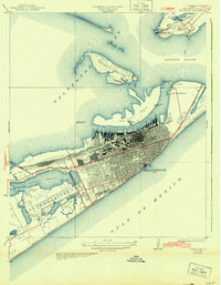
1933 Map of Galveston
USGS Topo · Published 1943About this map
Galveston and the Bolivar Peninsula appear in high detail during the early 1930s, showing a city deeply integrated with its maritime and military infrastructure. The bustling harbor at Galveston Channel is lined with dozens of numbered piers, from Pier 10 to Pier 41, supported by a complex rail network including the Southern Pacific and G C & S F lines terminating at Union Sta. This period reflects the city's strategic importance, anchored by Fort Crockett on the western shore and Fort Travis guarding the entrance to Bolivar Roads.
Find a feature on this map
65 named features on this map. Tap any name to fly to it.
Don’t see what you’re looking for? This feature index may not catch every label — zoom into the map to look around manually.
Map Details
Editions of this 1933 Galveston Map
This is the sole edition of this map. No revisions or reprints were ever made.
Other maps of this area

1929 · Virginia Point
USGS Topo · 1:24,000

1929 · Texas City
USGS Topo · 1:24,000

1930 · Galveston
USGS Topo · 1:24,000

1931 · Lake Como
USGS Topo · 1:24,000

1931 · Flake
USGS Topo · 1:24,000

1932 · Texas City
USGS Topo · 1:31,680

1932 · Bolivar Point
USGS Topo · 1:24,000

1932 · Virginia Point
USGS Topo · 1:31,680

1933 · The Jetties
USGS Topo · 1:31,680

1933 · Bolivar Point
USGS Topo · 1:31,680