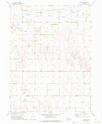
1972 Map of Gandy
USGS Topo · Published 1975About this map
Gandy occupies a central position in this Logan County landscape, situated just south of the South Loup River valley. The presence of the Union Pacific railroad, including the Gandy (Station), highlights the historical importance of rail transit to this Nebraska ranching community. The map reveals a transition from the river bottomlands to the dissected terrain of the Sandhills, marked by several local burial sites including St Johns Cem, McCain Cem, and Garfield Cem further south near the Logan Co Lincoln Co line. Small-scale aviation markers like the Bay Landing Strip and Brosius Landing Strip suggest the expansive nature of local operations such as the Milldale Ranch, where transportation shifted between rail and private air to manage the distances of the Nebraska interior.
Find a feature on this map
13 named features on this map. Tap any name to fly to it.
Don’t see what you’re looking for? This feature index may not catch every label — zoom into the map to look around manually.
Map Details
Editions of this 1972 Gandy Map
This is the sole edition of this map. No revisions or reprints were ever made.
Other maps of this area

1899 · North Platte
USGS Topo · 1:125,000

1902 · North Platte
USGS Topo · 1:125,000

1949 · Cody Lake
USGS Topo · 1:62,500

1951 · Cody Lake
USGS Topo · 1:62,500

1951 · Hoagland
USGS Topo · 1:62,500

1954 · North Platte
USGS Topo · 1:250,000

1956 · North Platte
USGS Topo · 1:250,000

1957 · North Platte
USGS Topo · 1:250,000

1967 · North Platte
USGS Topo · 1:250,000
1972 · Stapleton
USGS Topo · 1:24,000