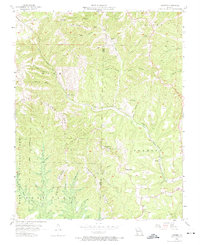
1956 Map of Garber
USGS Topo · Published 1974About this map
Marvel Cave and the folklore-rich landscape of the Ozarks define this mid-century survey along the Stone and Taney County line. The map highlights the cultural geography of the area, featuring Inspiration Point Old Matt's Cabin, a cornerstone of local literary history. The Missouri Pacific railroad winds through the narrow valleys, connecting small settlements like Garber and Notch. High points such as Dewey Bald and the Reeds Spring Lookout Tower overlook a terrain characterized by deep hollows like Deer Lick Hollow and Mutton Hollow. The transition of the era is evident in the presence of both the Garber Sch (Abandoned) and the emerging infrastructure at Branson Memorial Airport, complete with a nearby Drive-in Theater and Racetrack, signaling the early growth of the region's recreation and tourism economy.
Find a feature on this map
43 named features on this map. Tap any name to fly to it.
Don’t see what you’re looking for? This feature index may not catch every label — zoom into the map to look around manually.
Map Details
Editions of this 1956 Garber Map
3 editions found
Other maps of this area

1907 · Forsyth
USGS Topo · 1:125,000

1945 · Harrison
USGS Topo · 1:250,000

1949 · Harrison
USGS Topo · 1:250,000

1950 · Garber
USGS Topo · 1:24,000

1954 · Harrison
USGS Topo · 1:250,000

1955 · Day
USGS Topo · 1:24,000

1956 · Lampe
USGS Topo · 1:24,000

1956 · Table Rock Dam
USGS Topo · 1:24,000

1956 · Garber
USGS Topo · 1:24,000
1956 · Spokane
USGS Topo · 1:24,000